
The month of May 2025 will be remembered as one of Australia’s most dramatic examples of weather whiplash, where the continent simultaneously experienced two completely opposite meteorological phenomena. While New South Wales battled catastrophic flooding that claimed five lives and isolated tens of thousands, southern regions of Australia were gripped by some of the most severe drought conditions ever recorded. This tale of two extremes perfectly illustrates how climate change is reshaping Australia’s weather patterns in increasingly unpredictable and dangerous ways.

The NSW Flood Crisis: When the Sky Opens
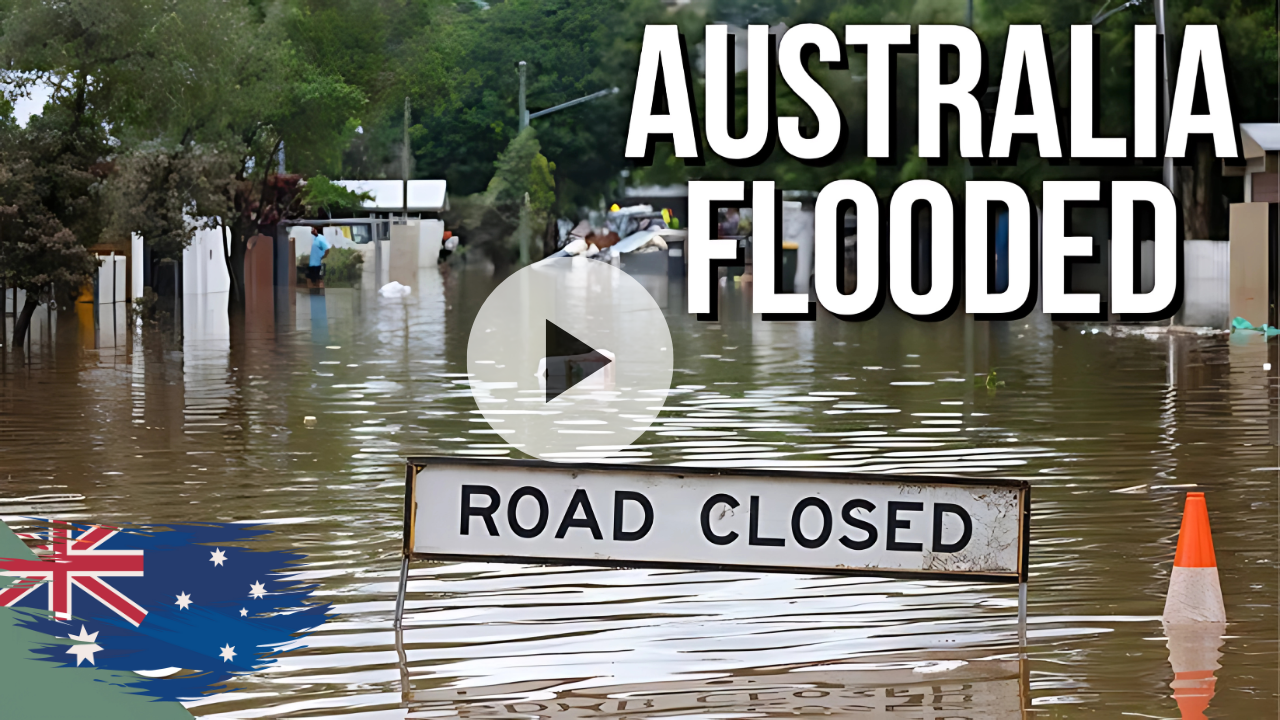
Record-Breaking Deluge Hits Mid North Coast
The coastal town of Taree became the epicenter of what meteorologists are calling a once-in-500-year flooding event. Receiving 427 millimetres (16.8 in) of rain over two days, Taree had the wettest May on record and experienced one-third of its annual average rainfall from 19 to 21 May. The Manning River surged to unprecedented heights, surpassing the 1929 record of six metres early this morning and is still rising.
The meteorological setup that created this disaster was both unusual and persistent. The main causes of the heavy rainfall were a near-stationary low pressure trough over the eastern seaboard in the Pacific Ocean, which barely moved over the span of four days, that was cooperating with a static pool of cold upper-level air and unyielding stream of moisture-laden, easterly winds brought by a high pressure system in the southern Tasman Sea.
Human Cost and Emergency Response
The human toll was devastating. Caused by a slow-moving low pressure system and killing five people, it is the worst flood disaster in Mid North Coast region. Emergency services mounted one of the largest rescue operations in recent Australian history. Emergency services carried out 284 flood rescues in the Mid North Coast and Hunter region, after 300 millimetres (12 in) of rain falling in the region in less than 24 hours.
The scale of isolation was staggering. New South Wales Premier Chris Minns said during a media briefing. “There’s 140 flood warnings, 50,000 people are in the range where they have been asked to prepare to evacuate and could be isolated, and there’s been 9,500 properties in the direct vicinity”. Communities found themselves completely cut off from the outside world, with residents like Nicole Sammut, a nurse at an aged care facility, telling reporters she “came to work on Tuesday and haven’t left.”
Infrastructure and Economic Impact
The floods wreaked havoc on critical infrastructure across the region. Major highways were submerged, cutting off access to essential supplies and emergency services. Dead and lost livestock had washed up on the coast after the floods inundated several farms and homes. The dairy industry, vital to the region’s economy, suffered particularly severe losses that Prime Minister Anthony Albanese warned would have nationwide impacts.
The Southern Drought: A Parched Landscape
Unprecedented Dryness Grips the South
While northern NSW was drowning, Australia’s southern regions were experiencing the opposite extreme. Swathes of South Australia, Victoria, Tasmania and Western Australia are in the grip of drought as they experience some of the lowest rainfall totals on record. The contrast couldn’t have been more stark – as flood rescues were underway hundreds of kilometers to the north, farmers in the south were watching their crops wither and their livestock struggle.
The drought’s grip was tightening with each passing day. Agricultural communities that form the backbone of Australia’s food production were facing impossible decisions. Farmers are spending eye-watering amounts of money buying feed, or selling stock to stay afloat. In some regions, the situation was so dire that water had to be trucked in to fill empty rainwater tanks and dams, particularly in the Adelaide Hills.
The Science Behind the Divide
What made May 2025’s weather so extreme was the persistent nature of the atmospheric patterns. These kinds of weather systems have been notably absent from southern Australia in recent months. Instead, slow-moving high-pressure systems, which typically bring warm and dry conditions, have been the standout feature across southern Australia. Meanwhile, the same slow-moving systems that brought drought to the south were feeding moisture into the devastating low-pressure system affecting NSW.
Climate Change: The Common Thread
Intensifying Weather Patterns
Both extremes were amplified by the underlying effects of climate change. As the climate heats, the global atmosphere holds more moisture. The total amount of water vapour in the atmosphere reached a record value in 2024, at about 5% above the 1991–2020 average. This increased atmospheric moisture capacity means that when conditions are right for rainfall, the results can be catastrophic.
Research shows that Australia is experiencing significant changes in extreme weather patterns. We are experiencing: 7-28% more rain for shorter duration rainfall events (the type of events associated with flash flooding). This represents a dramatic increase from previously used planning standards and suggests that current infrastructure may be inadequate for future extreme events.
Ocean Temperature Anomalies
The oceans surrounding Australia played a crucial role in both extremes. Since July 2024, SSTs have been the warmest or second warmest on record for each respective month. These elevated sea surface temperatures provide additional energy for storm systems while also contributing to increased evaporation and atmospheric moisture content.
Historical Context and Future Implications
Australia’s Climate Whiplash Pattern
Australia has always experienced variable weather, but the intensity and speed of transitions between extremes are increasing. As a nation, we are experiencing “climate whiplash” – being hurled violently from one extreme to another. The May 2025 events perfectly exemplify this phenomenon, where regions separated by relatively short distances experienced completely opposite conditions simultaneously.
Adaptation Challenges
The contrasting extremes present unique challenges for government planning and community preparedness. How do you prepare infrastructure for both catastrophic flooding and severe drought? How do emergency services allocate resources when facing simultaneous but opposite crises?
Preparing for the New Normal
Infrastructure Adaptation
The events of May 2025 highlight the urgent need for infrastructure that can handle both extremes. Traditional flood management systems proved inadequate against the intensity of the NSW deluges, while drought-stricken regions struggled with water security despite being relatively close to flood-affected areas.
Emergency Response Evolution
Emergency services demonstrated remarkable adaptability during the crisis, but the simultaneous nature of the extremes stretched resources thin. Future planning must account for the possibility of multiple, contrasting disasters occurring simultaneously across the continent.
The month of May 2025 served as a stark reminder that Australia’s climate is entering uncharted territory. The juxtaposition of record-breaking floods and severe drought within the same timeframe and relatively small geographic area represents a new paradigm that will require fundamental changes in how the nation prepares for and responds to extreme weather.
As Australia grapples with these increasingly frequent climate whiplash events, the lessons learned from May 2025 will prove invaluable. The resilience shown by communities facing both extremes demonstrates the Australian spirit, but it also underscores the urgent need for comprehensive climate adaptation strategies that can handle whatever extremes the future may bring.
Frequently Asked Questions
Q: What caused the simultaneous flooding and drought in Australia during May 2025?
A: Persistent atmospheric patterns created by slow-moving high-pressure systems caused drought in the south while feeding moisture into a stationary low-pressure system that brought record flooding to NSW.
Q: How does climate change contribute to these weather extremes?
A: Climate change increases atmospheric moisture capacity by 7% per degree of warming, leading to more intense rainfall events and longer, more severe droughts.
Q: Will these types of simultaneous extreme events become more common?
A: Yes, scientists predict that climate whiplash events will increase in frequency and intensity as global temperatures continue to rise.
Reference: Multiple Bureau of Meteorology reports, NSW SES statements, and peer-reviewed climate research from Australian institutions.