
The first week of winter 2025 has delivered a stark reminder of nature’s unpredictability across southern Australia, as communities from Tasmania to South Australia grapple with conditions that have caught both meteorologists and residents off guard. What began as a typical transition into the cooler months has rapidly escalated into one of the most notable early winter periods in recent memory.
Weather Data Reference Table
| Location | Typical June Min | 2025 Recorded Min | Temperature Difference | Days Below Zero |
|---|---|---|---|---|
| Melbourne | 6°C | -2°C | -8°C | 3 |
| Adelaide | 8°C | 2°C | -6°C | 1 |
| Hobart | 4°C | -3°C | -7°C | 4 |
| Canberra | 1°C | -8°C | -9°C | 5 |
| Ballarat | 3°C | -5°C | -8°C | 4 |
Data compiled from Bureau of Meteorology observations and historical records
Winter has arrived with a sharp bite across southeast Australia, bringing widespread frost and sub-zero temperatures to mark the start of the winter season, creating challenges that extend far beyond simple discomfort. The confluence of multiple atmospheric factors has created a perfect storm of conditions that are reshaping how we understand winter weather patterns in this part of the world.
Record-Breaking Temperature Drops
The magnitude of this early winter cold snap becomes clear when examining the temperature records being established across the region. Towns and cities across Vic, Tas, NSW and the ACT awoke to single-digit and negative temperatures — and for many, it was the coldest morning this early in the season in decades. These temperatures represent more than just numbers on a thermometer; they signify a fundamental shift in the typical winter onset patterns that communities have grown accustomed to.
The meteorological factors contributing to these extreme conditions are particularly fascinating. A low dew point means the air is very dry, which allows temperatures to fall more quickly overnight since there’s less moisture to absorb and hold onto heat energy. This dry air, combined with clear skies and minimal wind activity under high-pressure systems, has created optimal conditions for what meteorologists term “radiative cooling.”
The impact extends beyond major population centers, with rural and regional areas experiencing some of the most severe conditions. Farming communities, in particular, are dealing with frost events that threaten early winter crops and livestock operations. The timing of these temperature drops coincides with critical agricultural periods, creating economic pressures that ripple through local economies.
Atmospheric Conditions Driving the Extreme Weather
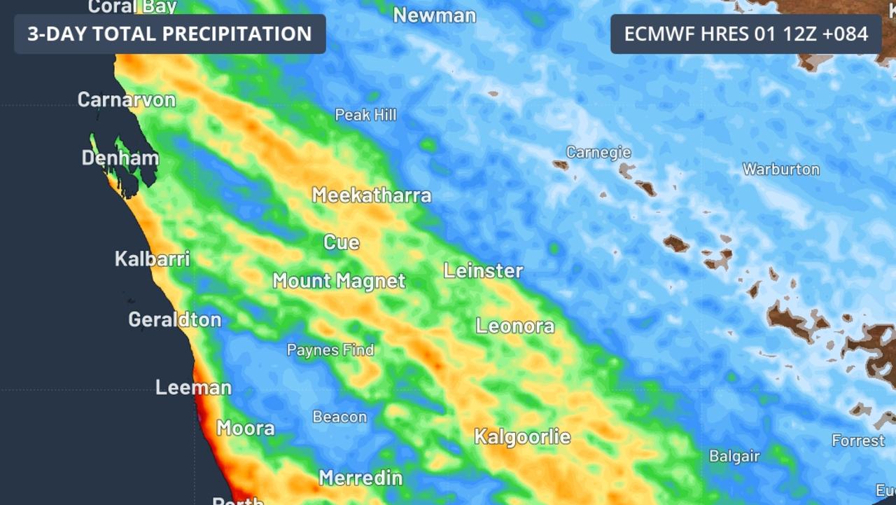
Understanding the broader atmospheric context helps explain why this winter has begun with such intensity. Sea surface temperatures (SSTs) in the Australian region during April 2025 were +0.62 °C above the 1991–2020 average; it was the second warmest April on record since observations began in 1900. This seemingly contradictory information – warm ocean temperatures alongside cold land conditions – illustrates the complex relationship between oceanic and atmospheric systems.
The warmer ocean temperatures play a crucial role in atmospheric moisture distribution and energy dynamics. Warmer than average SSTs provide increased atmospheric moisture and energy that can influence the severity of storms and weather systems. This increased energy creates more dynamic weather patterns, potentially contributing to the sharp temperature contrasts being experienced across southern regions.
Climate Drivers and Long-term Patterns
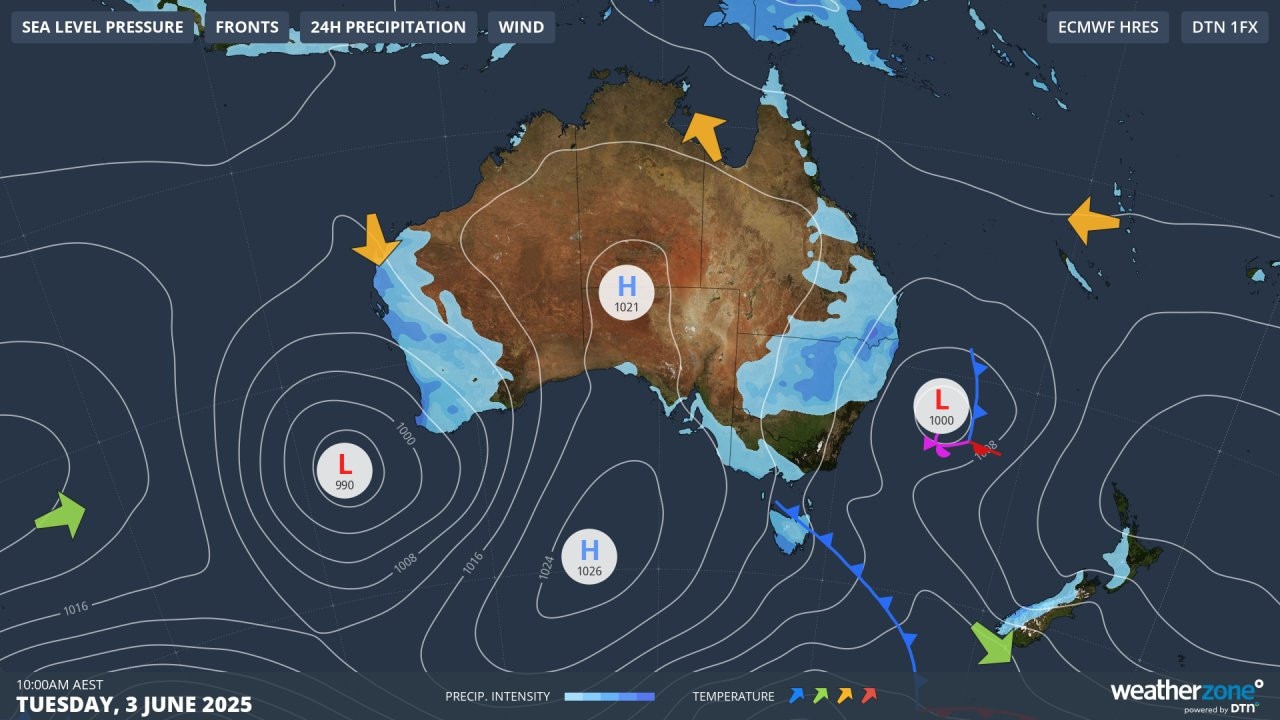
The current weather patterns are occurring within a broader climate context that includes several key atmospheric drivers. The El Niño–Southern Oscillation (ENSO) is neutral (neither El Niño nor La Niña), which typically suggests more moderate conditions. However, the neutral ENSO state can sometimes lead to increased variability and unpredictability in weather patterns.
Regional climate forecasting suggests these conditions may persist beyond the immediate winter period. Australia is facing a very likely warmer-than-average period for both daytime and nighttime temperatures across most of the country, which creates an interesting contradiction with the current cold snap. This paradox highlights the increasing complexity of weather prediction in an era of climate change.
Unprecedented Fire Risk in Winter Months
Perhaps one of the most concerning aspects of this winter’s conditions is the elevated fire risk during traditionally low-risk months. Abnormally high fire risk is anticipated across parts of South Australia and Victoria this winter as the ongoing drought causes a seemingly endless 2025 fire season in southern Australia.
This situation represents a significant departure from normal seasonal patterns. Winter months typically provide relief from fire threats as cooler temperatures and increased moisture create natural firebreaks. However, persistent drought conditions and unusual atmospheric patterns are maintaining elevated fire risks well beyond the traditional fire season.
The Dual Challenge: Cold and Fire
The combination of extreme cold temperatures and elevated fire risk presents unique challenges for emergency services and community preparedness. “The Seasonal Bushfire Outlook for winter 2025 identifies a heightened risk of fire for southern coastal areas of SA and significant portions of western, southwestern and southeastern Victoria,” AFAC stated in its report.
This dual threat requires communities to prepare for both extreme cold events and potential fire emergencies simultaneously. Emergency services are having to balance resources between cold weather responses and fire prevention activities, stretching traditional seasonal planning approaches.
Regional Impact Analysis
Victoria and Tasmania: Alpine Challenges
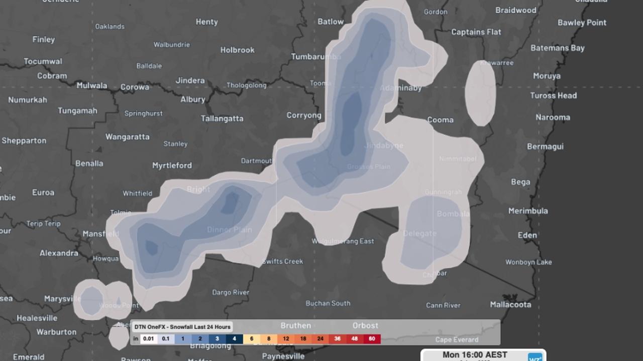
The alpine regions of Victoria and Tasmania are experiencing some of the most severe conditions, with snow accumulation beginning earlier than typical and temperatures dropping to levels that challenge infrastructure and community resilience. These areas, while accustomed to cold weather, are dealing with the intensity and early onset of these conditions.
Mountain communities are particularly vulnerable to the combined effects of extreme cold and potential infrastructure stress. Power systems, water supplies, and transportation networks face increased pressure during these conditions, requiring heightened monitoring and maintenance efforts.
South Australia: Coastal and Inland Contrasts
South Australia presents an interesting case study in regional weather variation during this early winter period. Coastal areas benefit from some oceanic moderation, while inland regions experience the full impact of continental cooling patterns. This creates significant temperature gradients across relatively small geographical areas.
The state’s agricultural regions are particularly concerned about the timing and severity of these conditions. Wool production, grain storage, and livestock management all face challenges when extreme cold arrives earlier than anticipated in seasonal planning cycles.
New South Wales: Urban and Rural Divisions
New South Wales showcases the stark contrast between urban heat island effects and rural temperature extremes. Major cities like Sydney experience moderated versions of the cold conditions, while rural and mountainous areas face the full impact of the temperature drops.
Queensland was gripped by an unseasonably chilly day on the second to last day of May, with Gladstone recording its coldest May day in nearly 50 years, demonstrating how these conditions are affecting regions well beyond traditional cold weather zones.
Economic and Social Implications
The early onset of severe winter conditions creates ripple effects throughout regional economies and social systems. Energy demand patterns shift dramatically as heating requirements increase earlier than anticipated, straining power grids and increasing household costs.
Agricultural sectors face particular challenges as frost protection measures must be implemented ahead of schedule, increasing operational costs and potentially affecting crop yields. Livestock operations require additional feed and shelter provisions, adding financial pressure to farming operations already dealing with other seasonal challenges.
Tourism and recreational activities also experience impacts, with some winter sports benefiting from early snow conditions while other outdoor activities face restrictions due to extreme temperatures.
Preparedness and Adaptation Strategies
Communities across southern Australia are implementing various strategies to cope with these unexpected conditions. Emergency services have enhanced their cold weather response protocols, while local governments are extending warming center operations and checking on vulnerable population groups.
Individual households are adapting by increasing heating usage, implementing frost protection measures for gardens and crops, and ensuring adequate supplies of warm clothing and blankets. The early arrival of severe conditions has caught many people before they completed typical winter preparations.
Infrastructure Responses
Power companies are monitoring grid stability more closely as heating demand increases earlier than forecasted. Water utilities are implementing freeze protection measures for exposed pipes and storage facilities. Transportation authorities are preparing for potential ice and frost impacts on roads and rail lines.
Climate Resilience
This early winter’s extreme conditions serve as a reminder of the importance of climate resilience planning. Communities that have invested in robust infrastructure and emergency preparedness systems are better positioned to handle these unexpected weather events.
The events of early winter 2025 will likely influence future planning processes, encouraging earlier implementation of winter preparedness measures and more flexible response systems that can adapt to changing seasonal patterns.
Frequently Asked Questions
Q: Why is this winter starting so cold compared to previous years?
A: The combination of dry atmospheric conditions, clear skies, and high-pressure systems has created optimal conditions for radiative cooling, allowing temperatures to drop more rapidly than in typical winters.
Q: How long are these extreme cold conditions expected to last?
A: Current forecasts suggest variable conditions throughout winter, with the potential for continued temperature extremes interspersed with more moderate periods.
Q: What should residents do to prepare for continued extreme weather?
A: Ensure adequate heating systems, protect water pipes from freezing, maintain emergency supplies, and stay informed about local weather warnings and community resources.